

|
|
|
|
Welcome! New Site Under Construction!
This site is a new work in progress and is part of the MOGenWeb Project and the USGenWeb Project. As you view this site, you will be able to see the basic layout of the site, but not all links are active at this point. As information is uploaded, the links will be activated.
This site will be family focused and provide opportunities for you to contribute the data that you have collected.
Oregon County Missouri History
A sign at the courthouse in Alton reads:
|
Oregon County |
|
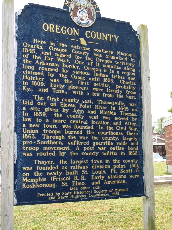 |
Here
in the extreme southern Missouri Ozarks, Oregon County was organized
in 1845, and named for the Oregon territory of the Far West. One of
11 counties along the Arkansas border, Oregon is in a region claimed
by the Osage until 1808. Charles Hatcher was the first settler,
probably in 1809. Early pioneers were largely from Ky., and Tenn.,
with a few from the East. |
Search this site:
| search engine by freefind | advanced |
LINKS - This page is not attempting to duplicate the information that already exists on the web. Our mission is to add to what is already found. Please check out these links that might be helpful to those researching in Oregon County, Missouri.
© 2018 by Denise Woodside or individual contributors as shown. No portion of this site is to be considered public domain and is not to be reproduced for any purpose without express written consent of the owner of the material.